

Science in orbit, Safety on Earth
On July 29, the Earth jolted violently as an 8.8-magnitude earthquake struck Russia’s Kamchatka Peninsula — one of the most powerful seismic events in recent years. Tremors rippled across the Pacific Ring of Fire and tsunami alerts flashed across coastal regions. Though widespread destruction was ultimately averted, the quake was a stark and timely reminder of the restless, unpredictable forces that lie beneath our feet.
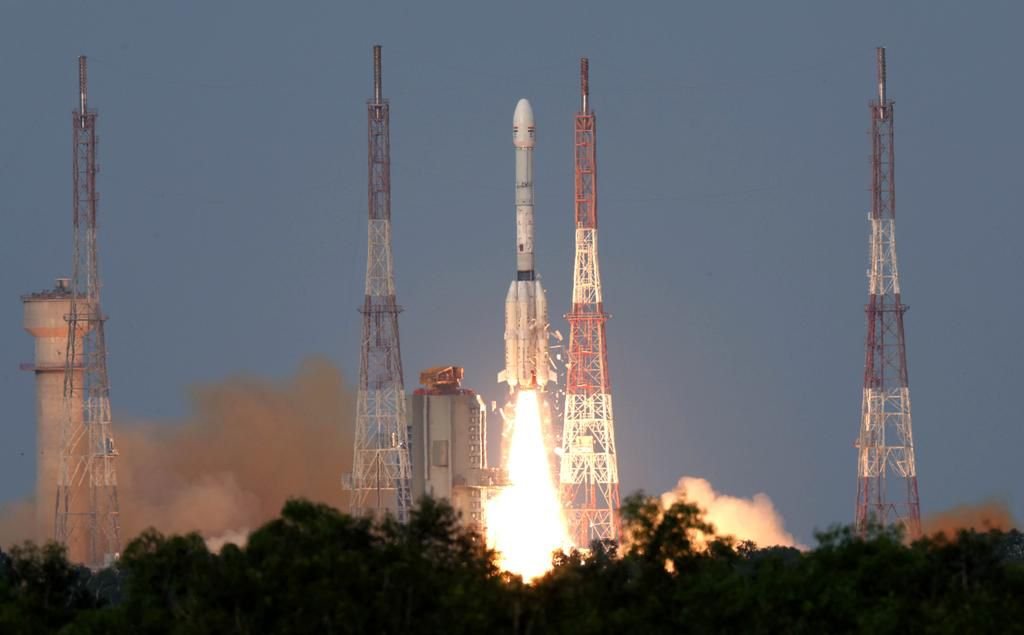
The very next day, on July 30, India launched a satellite that promises to make such surprises less surprising in the future. From the Satish Dhawan Space Centre in Sriharikota, the NASA-ISRO Synthetic Aperture Radar (NISAR) satellite soared into low Earth orbit aboard a GSLV Mark II rocket — a culmination of years of high-tech collaboration between the Indian Space Research Organisation (ISRO) and the US National Aeronautics and Space Administration (NASA).
NISAR isn’t just a satellite — it’s a planetary observatory in orbit, designed to monitor and measure the slow, invisible shifts that shape life on Earth and threaten it.
GSLV-F16/NISAR
From a majestic liftoff to the flawless separation, witness the full journey.
Watch spectacular moments of NISAR launching aboard GSLV-F16 and its precise separation, captured on-board.
A milestone in global space collaboration.#ISRO #NASA #GSLVF16 #NISAR pic.twitter.com/BZkqRujFHd
— ISRO (@isro) July 30, 2025
Earth in Motion: The Promise of NISAR
NISAR is the world’s first satellite equipped with dual-frequency synthetic aperture radar (SAR) — the L-band from NASA and the S-band from ISRO — enabling it to scan Earth’s surface in unprecedented detail. Orbiting 747 km above the planet, it will revisit the same location every 12 days, capturing changes as small as a few millimeters.
What this means, practically, is transformative. NISAR will be able to:
- Detect ground deformation in earthquake-prone zones
- Monitor glacier retreat in the Himalayas and Arctic
- Track vertical land movement along vulnerable coastlines
- Map landslide-prone regions and active fault lines
- Measure changes in forest biomass, soil moisture, wetlands and agricultural patterns
- Track urban land subsidence due to groundwater overuse
In short, NISAR will let us see the Earth breathe, shift and strain — long before cracks become catastrophes.
The Russia Quake: A Timely Warning
The 8.8-magnitude earthquake on July 29, near the Kamchatka Trench, was not just a seismic event — it was an eerie prologue to NISAR’s launch. It reminded the world of how suddenly the Earth can move, and how devastating the consequences can be when we’re caught unprepared.
India, too, is vulnerable. Vast swathes of the country lie in Seismic Zones IV and V, including the entire Himalayan belt, parts of the Northeast and even densely populated cities like Delhi. A similar quake in the Indo-Gangetic plains or the Andaman region could have far deadlier consequences. But unlike past decades, we now have the tools to watch — and possibly anticipate — such events.
NISAR’s radar can detect the slow buildup of tectonic stress, sometimes years in advance. By creating a dynamic deformation map of the Earth’s crust, it allows scientists and disaster planners to model high-risk zones more accurately and issue early warnings for earthquakes, landslides and even tsunamis triggered by seafloor shifts.
Tsunamis, Subsidence and the Indian Context
India’s 7,500-km coastline — home to over 250 million people — is also at risk from undersea quakes and land subsidence. Cities like Chennai, Mumbai and Kolkata are already witnessing gradual sinking due to aquifer depletion, construction stress and sea-level rise.
NISAR will track this vertical land motion with radar-based precision, helping coastal planners prepare for inundation, adapt urban infrastructure and improve resilience in the face of rising seas.
It will also be crucial for understanding deltaic shifts in the Sundarbans, Mahanadi and Godavari basins, where changing sediment patterns threaten livelihoods and ecosystems.
Climate Resilience: From Glaciers to Forests
While earthquakes and tsunamis are sudden disasters, climate change is a slow-motion catastrophe. NISAR’s ability to map ice mass loss, track glacier movement and monitor forest cover makes it a vital tool for:
- Assessing Himalayan snowpack and its link to water security
- Detecting changes in carbon storage across central India’s forests
- Monitoring the health of wetlands like Kolleru, Chilika and Loktak
- Supporting adaptation efforts in drought – and flood – prone regions
The satellite will also help India report and verify its climate commitments under the Paris Agreement by generating hard data on land use, emissions sinks and ecosystem health.
ISRO–NASA: A Space Partnership of Equals
Technically, NISAR is one of the most sophisticated Earth observation satellites ever built. Diplomatically, it is historic. This is the first satellite co-developed and co-funded by NASA and ISRO — with each agency contributing roughly $500 million and key systems.
NASA built the L-band radar and mission systems; ISRO developed the satellite bus, S-band radar and managed the successful launch. The mission represents a 50:50 partnership — not just in budget, but in trust, expertise and vision.
At a time when outer space is becoming contested and militarised, NISAR offers a rare model of democratic cooperation for planetary good.
From Orbit to Action: The Challenge of Application
NISAR’s data will be made freely available — a radical move in a world where commercial satellite imagery often comes at a premium. But data alone does not save lives — its impact depends on how well it is interpreted and applied.
India must now:
- Build local expertise to analyse and act on satellite insights
- Strengthen GIS and disaster response systems at state and district levels
- Develop AI-based platforms to process continuous radar imagery
- Train urban planners, agricultural experts and climate professionals in satellite-based decision-making
Without these steps, the promise of NISAR risks staying in orbit, never touches the ground where it matters most.
A New Orbit for India’s Space Story
For ISRO, NISAR signals a coming-of-age moment. After dazzling the world with its low-cost Mars orbiter, successful Moon missions and upcoming human spaceflight programme, ISRO is now stepping into a new role: global collaborator and co-creator of cutting-edge scientific missions.
With Gaganyaan on the horizon and India’s private space sector beginning to blossom, NISAR adds scientific credibility, strategic depth and diplomatic heft to India’s space portfolio.
Listening to the Earth’s Signals
As the Earth continues to warm, shake and rise, the signals are all around us. Some are violent, like the 8.8-magnitude quake in Russia. Others are subtle — a glacier thinning, a delta shifting, a coastline sinking.
With NISAR now watching from orbit, we have a better chance of reading those signals — not after the disaster, but before.
More than a satellite, NISAR is a partnership. A promise. A planetary early-warning system powered by science and trust. In an uncertain world, it may help us do the most certain thing of all: prepare.
About the Author
Mr. Hridaya Mohan (hridayamohan@yahoo.co.in) is a regular Columnist with a renowned Indian daily “The Hitavada”, “Bharat Neeti Media” and some other newspapers / magazines internationally. Superannuated as Executive Director, Steel Authority of India Ltd. (SAIL), he is Senior Adviser, Metallon Holdings Pvt. Ltd. presently. He headed SAIL office at Beijing as Chief Representative (China & Mongolia) for six years. He has published and presented seventeen papers globally. Recipient of “Sir M Visvesvaraya Gold Medal“for one of his papers, “Benchmarking of Maintenance Practices in Steel Industry” from The Institution of Engineers (India), he was awarded with “Scroll of Honour” for the excellent contributions to Engineering fraternity from IE(I), Bhilai, “Jawahar Award” for leadership excellence in SAIL and “Supply Chain Leader – 2017” award from IIMM. The writer lived and worked in Beijing for 6 long years as Chief Representative (China & Mongolia), SAIL.